The Hydrographic Survey division within Anderson Knight provides high quality recruitment solutions for the various disciplines within the field.
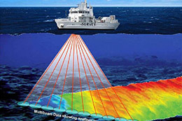
Hydrography refers to the mapping or charting of water's topographic features. It involves measuring the depths, tides, and currents of a body of water and establishing the topography and morphology of seas, rivers, and lake beds. Normally and historically the purpose of charting a body of water is for the safety of shipping navigation. Such charting includes the positioning and identification of things such as wrecks, reefs, structures (platforms etc.), navigational lights, marks and buoys and coastline characteristics.
Hydrographic survey is the science of measurement and description of features which affect maritime navigation, marine construction, dredging, offshore oil exploration/drilling and related activities. Strong emphasis is placed on soundings, shorelines, tides, currents, sea floor and submerged obstructions that relate to the previously mentioned activities. The term Hydrography is sometimes used synonymously to describe Maritime Cartography, which in the final stages of the hydrographic process uses the raw data collected through hydrographic survey into information usable by the end user.
Positions Covered Include:
Online Surveyors
Data Processors
Survey Engineers
Party Chiefs
Report Coordinators
Geophysicists Location: Worldwide
Job added by Anderson Knight ltd
Note! Companies never receive or ask for money from seafarers! Read more about Scam Jobs
About Anderson Knight ltd
Anderson Knight is an Independent Resource Consultancy
Our specialist consultants all have one purpose in mind when they sit at their desks each morning.
They want to turn recruitment into results - for both candidate and client.
Being qualified within their specific specialist field, their e Read more